Every station, access road, dig site, vendor, machine, and driver: on one map the entire company works from. Import what the operator gives you, draw what's missing, track what moves, and dispatch from the same screen.
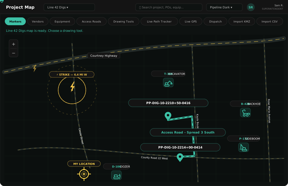
Most mapping tools show you where things are. The Project Map is built for what pipeline crews actually do with that information: find it, reach it, mark it, move it.

Load operator-provided KMZ files straight onto the map, or import CSV files with longitude/latitude coordinates: stations, access roads, anomaly dig sites, HDD entry and exit points, and ROW boundaries. What used to live in a folder of attachments becomes a layer every crew can see. Toggle layers on and off per job.

Search vendors in the area around your spread and pin them where they sit: fuel, water, mats, rock, welding supply, and rental yards. When a foreman needs something at station 2210+50, the closest option is a glance away, not a phone tree. Vendor pins carry contact info and tie back to the Vendor Marketplace.

Every machine on the job shows up with its unit tag, and its condition. See at a glance which excavator needs repair, which rental is pending off-rent, and exactly how to reach it: the access road to take, the gate to use, the ground between you and it. No more "it's out by the county road somewhere."

Draw access roads, mark gates, and flag soft ground and no-go areas: directly on the map, labeled and saved to the job. The road you drew Tuesday morning is on every driver's map Tuesday morning. Edits propagate instantly; nobody works off yesterday's picture.

The fastest way to map an access road is to drive it. Start the tracker on your phone or laptop, drive the route, and the path you traveled becomes a drawn access road on the project map: every turn, every fork, exactly as the ground actually runs. No sketching from memory back at the truck.

Stand next to a machine, a dig site, a valve, a gate, and capture its exact longitude and latitude right there. One tap pins the true coordinates to the map, tagged to the equipment or site record. The map reflects where things actually are, not where someone remembers leaving them.

Fleet vehicles and heavy equipment stream their positions onto the project map in real time: trucks by OBD device, iron by hardwired tracker. Watch the water truck approach the spread, confirm the sideboom made it to the next dig, and see the whole operation move against the pipe centerline.

Assign drivers pick-up and drop-off times and locations as pins, not addresses. The driver gets turn-by-turn to a point that means something on your job (the yard, the dig site, the stringing site) and the office watches status live: en route, arrived, unloaded, returning.
If it matters to the job, it's on the map, and if it's on the map, every crew can find it.
Want your fleet streaming onto a map like this?
5-Minute Fleet QuestionnaireThirty-minute walkthrough. Bring an operator KMZ from a real job and we'll put it on the map live: digs, roads, stations, and all.
Request a Demo